Police Footage of San Francisco's Oct 17 1989 Earthquake Aftermath Part 2
Police Footage of San Francisco's Oct 17 1989 Earthquake Aftermath Part 2
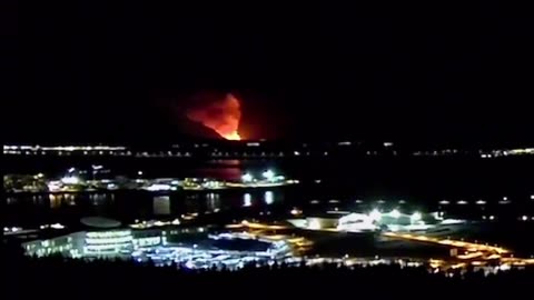
The 1989 Loma Prieta earthquake occurred on California's Central Coast on October 17 at 5:04 p.m. local time. The shock was centered in The Forest of Nisene Marks State Park in Santa Cruz County, approximately 10 mi (16 km) northeast of Santa Cruz on a section of the San Andreas Fault System and was named for the nearby Loma Prieta Peak in the Santa Cruz Mountains. With an Mw magnitude of 6.9 and a maximum Modified Mercalli intensity of IX (Violent), the shock was responsible for 63 deaths and 3,757 injuries
Damage was heavy in Santa Cruz County and less so to the south in Monterey County, but effects extended well to the north into the San Francisco Bay Area, both on the San Francisco Peninsula and across the bay in Oakland. No surface faulting occurred, though many other ground failures and landslides were present, especially in the Summit area of the Santa Cruz Mountains. Liquefaction was also a significant issue, especially in the heavily damaged Marina District of San Francisco, but its effects were also seen in the East Bay, and near the shore of Monterey Bay, where a non-destructive tsunami was also observed.[11]
Because it happened during a national live broadcast of the 1989 World Series, the annual championship series of Major League Baseball, taking place between Bay Area teams San Francisco Giants and the Oakland Athletics, it is sometimes referred to as the "World Series earthquake", with the championship games of the year being referred to as the "Earthquake Series". Rush-hour traffic on the Bay Area freeways was lighter than normal because the game, being played at Candlestick Park in San Francisco, was about to begin, and this may have prevented a larger loss of life, as several of the Bay Area's major transportation structures suffered catastrophic failures. The collapse of a section of the double-deck Nimitz Freeway in Oakland was the site of the largest number of casualties for the event, but the collapse of human-made structures and other related accidents contributed to casualties occurring in San Francisco, Los Altos, and Santa Cruz
313
views
1
comment
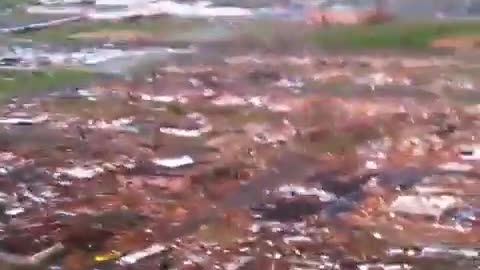
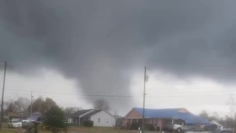
May 2011 Joplin, MO F5 Tornado Damage Aerials - 158 Deaths
The 2011 Joplin tornado was a large and devastating multiple-vortex tornado that struck Joplin, Missouri, United States, on the evening of Sunday, May 22, 2011. Part of a larger late-May tornado outbreak, the EF5 tornado began just west of Joplin and intensified very quickly, reaching a maximum width of nearly one mile (1.6 km) during its path through the southern part of the city.
The tornado devastated a large portion of the city of Joplin, damaging nearly 8,000 buildings, and of those, destroying over 4,000. The damage—which included major facilities like one of Joplin's two hospitals as well as much of its basic infrastructure—amounted to a total of $2.8 billion, making the Joplin tornado the costliest single tornado in U.S. history
Overall, the tornado killed 158 people (with an additional eight indirect deaths) and injured some 1,150 others. It ranks as one of the United States' deadliest tornadoes: it was the deadliest U.S. tornado since the April 9, 1947, F5 tornado in Woodward, Oklahoma
338
views
1
comment
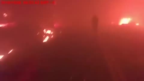
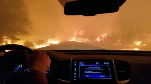
Body Cam Video - Camp Fire Rescue Paradise, CA Nov 2018
Butte County Sheriff's Deputy Aaron Parmley turned on his body-worn camera to capture what he though would be the last moments of his life. Four nurses needed help evacuating a hospital as the Camp Fire raged in Paradise, Calif
The Camp Fire was the deadliest and most destructive wildfire in California's history,and the most expensive natural disaster in the world in 2018 in terms of insured losses
255
views
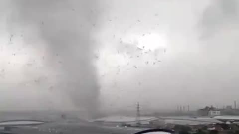
Strong Tornado Hits West Java, Indonesia
Strong Tornado hits West Java, Indonesia, injuring 33 people and damaging over 116 buildings.
Feb 21, 2024
268
views
1
comment
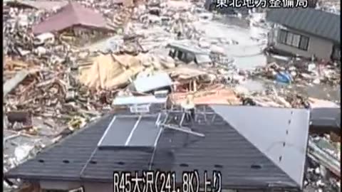
Surveillance Camera Footage of the 2011 Tsunami in Iwate Japan
Surveillance Camera Footage of the 2011 Tsunami in Iwate Japan
On March 11, 2011, Japan experienced the strongest earthquake in its recorded history. The earthquake struck below the North Pacific, 130 kilometers (81 miles) east of Sendai, the largest city in the Tohoku region, a northern part of the island of Honshu.
The Tohoku earthquake caused a tsunami. A tsunami—Japanese for “harbor wave”—is a series of powerful waves caused by the displacement of a large body of water. Most tsunamis, like the one that formed off Tohoku, are triggered by underwater tectonic activity, such as earthquakes and volcanic eruptions. The Tohoku tsunami produced waves up to 40 meters (132 feet) high, More than 450,000 people became homeless as a result of the tsunami. More than 15,500 people died. The tsunami also severely crippled the infrastructure of the country.
In addition to the thousands of destroyed homes, businesses, roads, and railways, the tsunami caused the meltdown of three nuclear reactors at the Fukushima Daiichi Nuclear Power Plant. The Fukushima nuclear disaster released toxic, radioactive materials into the environment and forced thousands of people to evacuate their homes and businesses
An upthrust of 6 to 8 metres (20 to 26 ft) along a 180 kilometres (110 mi) wide seabed at 60 kilometres (37 mi) offshore from the east coast of Tōhoku resulted in a major tsunami that brought destruction along the Pacific coastline of Japan's northern islands. Thousands of lives were lost and entire towns were devastated. The tsunami propagated throughout the Pacific Ocean region reaching the entire Pacific coast of North and South America from Alaska to Chile. Warnings were issued and evacuations were carried out in many countries bordering the Pacific. Although the tsunami affected many of these places, the heights of the waves were minor.
Chile's Pacific coast, one of the farthest from Japan at about 17,000 kilometres (11,000 mi) away, was struck by waves 2 metres (6.6 ft) high, compared with an estimated wave height of 38.9 metres (128 ft) at Omoe peninsula, Miyako city, Japan.
192
views
1
comment
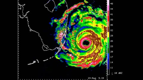
Cat 5 Hurricane Andrew Aug, 24 1992 Radar Animation at Landfall in Miami, FL
Radar animation from Miami, FL (MIA) WSR-57 radar at landfall
Hurricane Andrew was a compact, but very powerful and destructive Category 5 Atlantic hurricane that struck the Bahamas, Florida, and Louisiana in August 1992. It is the most destructive hurricane to ever hit Florida in terms of structures damaged or destroyed, and remained the costliest in financial terms until Hurricane Irma surpassed it 25 years later. Andrew was also the strongest landfalling hurricane in the United States in decades and the costliest hurricane to strike anywhere in the country, until it was surpassed by Katrina in 2005. In addition, Andrew is one of only four tropical cyclones to make landfall in the continental United States as a Category 5, alongside the 1935 Labor Day hurricane, 1969's Camille, and 2018's Michael. While the storm also caused major damage in the Bahamas and Louisiana, the greatest impact was felt in South Florida, where the storm made landfall as a Category 5 hurricane, with 1-minute sustained wind speeds as high as 165 mph (266 km/h) and a gust as high as 174 mph (280 km/h). Passing directly through the cities of Cutler Bay and Homestead in Dade County (now known as Miami-Dade County), the hurricane stripped many homes of all but their concrete foundations and caused catastrophic damage. In total, Andrew destroyed more than 63,500 houses, damaged more than 124,000 others, caused $27.3 billion in damage (equivalent to $59 billion in 2023),[nb 1] and left 65 people dead.
78
views
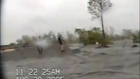
CRAZY RAW VIDEO Hurricane Katrina Roof Top Flooding St Bernard Parish LA Aug 2005
CRAZY RAW VIDEO Hurricane Katrina roof top flooding St Bernard LA
Raw Video of flooding beyond roof tops in St. Bernard Parish Louisiana DURING Katrina
Aug 29, 2005
Hurricane Katrina was a devastating and deadly Category 5 Atlantic hurricane that caused 1,836 fatalities and damages estimated between $97.4 billion to $145.5 billion in late August 2005, particularly in the city of New Orleans and its surrounding area. At the time, it was the costliest tropical cyclone on record, later tied by Hurricane Harvey in 2017. Katrina was the twelfth tropical cyclone, the fifth hurricane, and the third major hurricane of the 2005 Atlantic hurricane season. It was also the fourth-most intense Atlantic hurricane to make landfall in the contiguous United States, gauged by barometric pressure
Katrina began on August 23, 2005, with the merger of a tropical wave and the remnants of Tropical Depression Ten. Early the following day, the depression intensified into a tropical storm and headed generally westward toward Florida. On August 25, two hours before making landfall at Hallandale Beach, it strengthened into a hurricane. After briefly weakening to tropical storm strength over southern Florida, Katrina entered the Gulf of Mexico on August 26 and rapidly intensified. The storm strengthened into a Category 5 hurricane over the warm waters of the Gulf of Mexico before weakening to a high-end Category 3 hurricane at its second landfall on August 29 over southeast Louisiana and Mississippi.
The largest loss of life in Hurricane Katrina was due to flooding caused by engineering flaws in the flood protection system, particularly the levee around the city of New Orleans. Eventually, 80% of the city, as well as large areas in neighboring parishes, were flooded for weeks. The flooding destroyed most of New Orleans's transportation and communication facilities, leaving tens of thousands of people who did not evacuate the city prior to landfall with little access to food, shelter, and other basic necessities. The disaster in New Orleans prompted a massive national and international response effort, including federal, local, and private rescue operations to evacuate those displaced from the city in the following weeks. After the storm, multiple investigations concluded that the U.S. Army Corps of Engineers, which had designed and built the region's levees decades earlier, was responsible for the failure of the flood-control systems.[6] However, federal courts later ruled that the Corps could not be held financially liable due to sovereign immunity in the Flood Control Act of 1928
181
views
2
comments

Four People Were Hit by a Lightning Strike Close to the Sydney Opera House in Australia
Four people were hit by a Lightning strike close to the Sydney Opera House during a severe thunderstorm while taking refuge under a tree
Feb 18, 2024
157
views
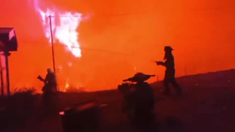
Praying While Escaping The Deadly Camp Fire in Butte County CA 2018
The Camp Fire was the deadliest and most destructive wildfire in California's history,[and the most expensive natural disaster in the world in 2018 in terms of insured losses
Cost
$16.65 billion (2018 USD)
Buildings destroyed
18,804
Deaths
85
224
views
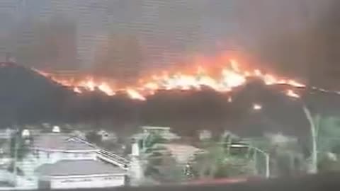
HELL APPROACHING: San Diego, Cedar Fire, Poway California. October 2003
The Cedar Fire was a massive, highly-destructive wildfire, which burned 273,246 acres (1,106 km2) of land in San Diego County, California, during October and November 2003. The fire's rapid growth was driven by the Santa Ana wind, causing the fire to spread at a rate of 3,600 acres (15 km2) per hour. By the time the fire was fully contained on November 4, it had destroyed 2,820 buildings (including 2,232 homes) and killed 15 people, including one firefighter. Hotspots continued to burn within the Cedar Fire's perimeter until December 5, 2003, when the fire was fully brought under control.
wildlands such as forest, rangelands or grasslands. These extreme events are common in the Western U.S., usually occurring in summer and fall. Wildfire season is defined by the dates of the first large fire and the last large fire control. Since the 1970s, the wildfire season in western states has extended from 5 months to over 7 months in length. Since the 1980s, the annual number of large fires and area burned has significantly increased, with a sizable proportion of the increase in fire activity occurring in the forests of the Northern Rocky Mountains, followed by forests in the Pacific northwest and southwest. In addition, the average burn time of individual fires has grown from 6 days between 1973 and 1982, to 52 days between 2003 and 2012. Increases in large fire activity and area burned have been driven by rising temperatures, reduced winter snowpack, earlier snowmelt, reduced summer precipitation and increased evaporation. Under climate change we can expect the wildfire activity to increase as temperatures continue to warm, lengthening the fire season further, and as drought continues to afflict wildland ecosystems
996
views
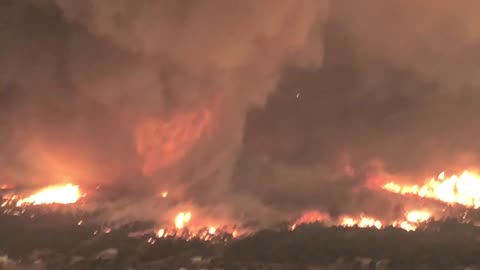
Fire Tornado during 2018 Carr Fire in Redding, CA
A powerful fire whirl with winds estimated in excess of 143 mph (230 km/h)—equivalent to an EF3 tornado—developed within the Carr Fire in Redding, California, on July 26. Remaining on the ground from 7:30–8:00 p.m., the fire whirl reached an estimated height of 18,000 ft (5,500 m) and caused extensive tornado-like damage while spreading the fire. The winds toppled transmission towers, shredded foliage, and debarked and uprooted trees. The smoke plume from the whirl dominated the site of the wildfire. Substantial damage occurred in areas untouched by fire, including signs of ground scouring.[41] Three people were killed inside their Redding home after the structure's walls were blown out and the roof collapsed on the occupants. Several other homes suffered significant roof damage
233
views
1
comment
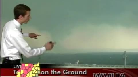
Tuscaloosa, Alabama EF4 Tornado April 27, 2011 - from Tower Camera
Tuscaloosa, Alabama Tornado April 27, 2011 - from Tower Camera at Bryant Denny Stadium
153
views
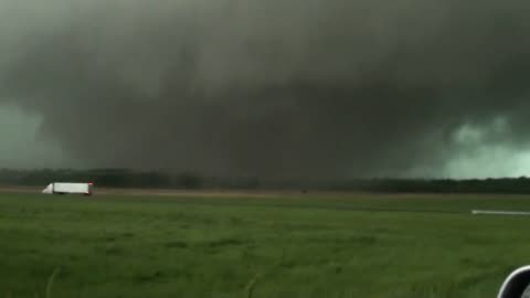
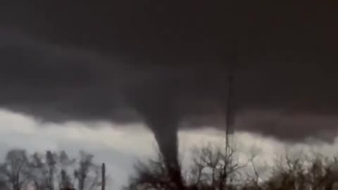
Large, EF-5 Tornado About to Cross I-65, Tanner, AL - April 27, 2011
Large, EF-5 Tornado About to Cross I-65, Tanner, AL - April 27, 2011
117
views
1
comment
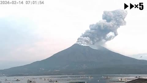
Eruption of the Sakurajima Volcano in Kagoshima Prefecture, Japan
Eruption of the Sakurajima volcano in Kagoshima Prefecture, Japan
Feb 14, 2024
151
views
1
comment
A landslide trapped at least nine workers at a gold mine in eastern Turkey
A landslide trapped at least nine workers at a gold mine in eastern Turkey, search and rescue efforts underway
Feb 13, 2024
89
views

Footballer Dies After Being Hit by Lightning in Indonesia
Footballer struck by lightning in Indonesia
Footballer dies after hit by lightning in Indonesia
There is no safe place outside when thunderstorms are in the area. If you hear thunder, you are likely within striking distance of the storm. Just remember, When Thunder Roars, Go Indoors. Too many people wait far too long to get to a safe place when thunderstorms approach.
221
views
2
comments
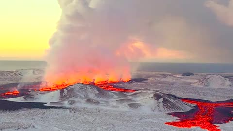
Another Angle of the Most Recent Iceland Volcanic Eruption
Another Angle of the Most Recent Iceland Volcanic Eruption
177
views
1
comment
Time Lapse of New Volcano Eruption in Iceland
Time lapse New volcano eruption in Iceland
Feb 8, 2024
174
views
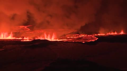
Volcano erupts in Iceland, 3rd eruption in 3 months
Volcano erupts in Iceland, 3rd eruption in 3 months on the Reykjanes Peninsula
158
views
LA firefighter dangling from helicopter rescues a man
LA firefighter dangling from helicopter rescues a man who jumped into treacherous waters looking for his dog during California storms
Feb 6, 2024
235
views
2
comments
Lightning Strike Hits Car
Lightning Strike Hits Car
More lightning strike videos
https://rumble.com/playlists/D0_4ihBsqK0
If you don’t have a Rumble account and would like to comment or subscribe make one below
https://rumble.com/register/F5Tornado/
12.9K
views
12
comments
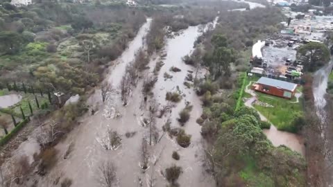
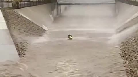
Drone footage of flooded Malibu Canyon
Drone footage of flooded Malibu Canyon and a bridge to community flooded over on north side of Malibu
Feb 5, 2024
386
views
1
comment
Wildfires in Chile have killed at least 112 people, deadliest in South American history
Wildfires in Chile have killed at least 112 people, making them the deadliest in South American history
133
views
1
comment