

The Size Difference of Tsunamis
The Size Difference of Tsunamis
A tsunami is a catastrophic ocean wave, usually caused by a submarine earthquake, an underwater or coastal landslide, or a volcanic eruption. Waves radiate outward from the generating impulse at speeds of up to 500 miles (800 km) per hour, reaching maximum heights of 100 feet (30 metres) near coastal areas. Although often called tidal waves, the occurrence of tsunamis have no connection with tides. The word tsunami is Japanese for “harbour wave.”
More geography related videos here
https://rumble.com/playlists/cYA64Dyo9DY
117
views
1
comment

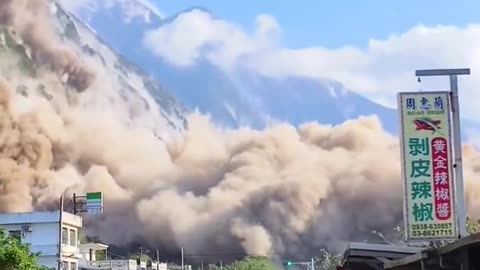
Moment building collapsed in Taiwan during powerful earthquake
Moment building collapsed in Taiwan during powerful earthquake
On 3 April 2024, at 07:58:11 NST (23:58:11 UTC on 2 April), a Mw 7.4 earthquake struck 18 km (11 mi) south-southwest of Hualien City, Hualien County, Taiwan. At least 17 people were killed and over 1,100 were injured in the earthquake. It is the strongest earthquake in Taiwan since the 1999 Jiji earthquake, with several aftershocks above Mw 5.0
Seventeen fatalities have been reported, along with a total of 1,145 people injured and 442 others declared stranded. Two people were listed as missing namely a couple carrying dual Australian and Singaporean nationality. The National Fire Agency recorded at least 1,151 earthquake-related incidents.
All fatalities occurred in Hualien County. Among the dead were four killed in Taroko National Park, including three hikers who were caught in a rockfall. Another person died when rockfalls occurred at the Daqingshui Tunnel along the Suhua Highway and crushed his truck. One person also died after their car was hit by a falling boulder at the parking lot of the Huide Tunnel along the Suhua Highway, while another fatality occurred inside a mine in Hejen after a rock fall. Five members of the same family were killed following a rockfall in Taroko National Park. along with a total of 1,145 people injured and 442 others declared stranded. A woman in Hualien died after she returned to her building to retrieve her cat, during which she was pinned down by a column following an aftershock. The cat was later found trapped between metal bars on a window of the building and was rescued on 9 April along with another cat that was also trapped on a window, during which demolition works were temporarily suspended
478
views
9
comments

7.4 quake hits TV studio during live broadcast In Taiwan
7. 4 quake hits TV studio during live broadcast In Taiwan
April 3, 2024
On 3 April 2024, at 07:58:11 NST (23:58:11 UTC on 2 April), a Mw 7.4 earthquake struck 18 km (11 mi) south-southwest of Hualien City, Hualien County, Taiwan. At least 17 people were killed and over 1,100 were injured in the earthquake. It is the strongest earthquake in Taiwan since the 1999 Jiji earthquake, with several aftershocks above Mw 5.0
Seventeen fatalities have been reported, along with a total of 1,145 people injured and 442 others declared stranded. Two people were listed as missing namely a couple carrying dual Australian and Singaporean nationality. The National Fire Agency recorded at least 1,151 earthquake-related incidents.
All fatalities occurred in Hualien County. Among the dead were four killed in Taroko National Park, including three hikers who were caught in a rockfall. Another person died when rockfalls occurred at the Daqingshui Tunnel along the Suhua Highway and crushed his truck. One person also died after their car was hit by a falling boulder at the parking lot of the Huide Tunnel along the Suhua Highway, while another fatality occurred inside a mine in Hejen after a rock fall. Five members of the same family were killed following a rockfall in Taroko National Park. along with a total of 1,145 people injured and 442 others declared stranded. A woman in Hualien died after she returned to her building to retrieve her cat, during which she was pinned down by a column following an aftershock. The cat was later found trapped between metal bars on a window of the building and was rescued on 9 April along with another cat that was also trapped on a window, during which demolition works were temporarily suspended
Live tv
1.04K
views
3
comments

Heavy shaking on the new Zhongzheng Bridge in Tapai, Taiwan, during the earthquake
Heavy shaking on the new Zhongzheng Bridge in Tapai, Taiwan, during the earthquake
April 3, 2024
768
views
Landslide in Taiwan after M7.5 Earthquake
Landslide in Taiwan after M7.5 Earthquake
April 3, 2024
407
views

Shaking as powerful 7.5 magnitude earthquake hits near Taiwan
Camera facing Taipei skyline shows massive shaking after powerful 7.5 magnitude earthquake hits near Taiwan
April 2, 2024
On 3 April 2024, at 07:58:11 NST (23:58:11 UTC on 2 April), a Mw 7.4 earthquake struck 18 km (11 mi) south-southwest of Hualien City, Hualien County, Taiwan. At least 17 people were killed and over 1,100 were injured in the earthquake. It is the strongest earthquake in Taiwan since the 1999 Jiji earthquake, with several aftershocks above Mw 5.0
Seventeen fatalities have been reported, along with a total of 1,145 people injured and 442 others declared stranded. Two people were listed as missing namely a couple carrying dual Australian and Singaporean nationality. The National Fire Agency recorded at least 1,151 earthquake-related incidents.
All fatalities occurred in Hualien County. Among the dead were four killed in Taroko National Park, including three hikers who were caught in a rockfall. Another person died when rockfalls occurred at the Daqingshui Tunnel along the Suhua Highway and crushed his truck. One person also died after their car was hit by a falling boulder at the parking lot of the Huide Tunnel along the Suhua Highway, while another fatality occurred inside a mine in Hejen after a rock fall. Five members of the same family were killed following a rockfall in Taroko National Park. along with a total of 1,145 people injured and 442 others declared stranded. A woman in Hualien died after she returned to her building to retrieve her cat, during which she was pinned down by a column following an aftershock. The cat was later found trapped between metal bars on a window of the building and was rescued on 9 April along with another cat that was also trapped on a window, during which demolition works were temporarily suspended
1.07K
views
1
comment
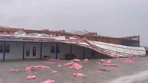
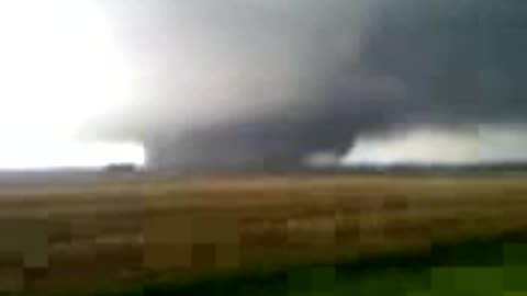
Damaging tornado hits New Castle, KY April 2, 2024
Damaging tornado hits New Castle, KY
April 2, 2024
122
views

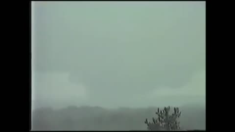
Tornado on the ground in Henry County KY. Lake Jericho area
Tornado on the ground in Henry County KY. Lake Jericho area
April 2, 2024
200
views
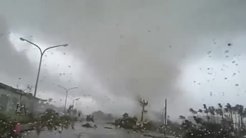
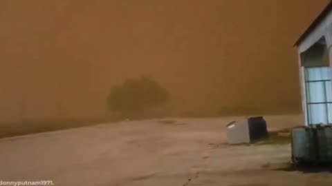
Significant tornado in Sunbright, TN April 2, 2024
Significant tornado in Sunbright, TN moments ago, significant damage is being reported in the town
640
views
Woman Appears to Be Thrown Out of a Tornado
Woman appears to be thrown out of a Tornado
A tornado is a violently rotating column of air extending from the base of a thunderstorm down to the ground. Tornadoes are capable of completely destroying well-made structures, uprooting trees, and hurling objects through the air like deadly missiles. Tornadoes can occur at any time of day or night and at any time of the year. Although tornadoes are most common in the Central Plains and the southeastern United States, they have been reported in all 50 states.
This website is designed to teach you how to stay safe when a tornado threatens. If you know what to do before, during and after a tornado, you will minimize your risk of injury and increase your chances of survival. You'll also find links to research, past events other topics of interest as well as downloadable safety handouts about thunderstorms, lightning, and tornadoes
Find out what you can do when a tornado strikes. Acting quickly is key to staying safe and minimizing impacts.
Stay Weather-Ready: Continue to listen to local news or a NOAA Weather Radio to stay updated about tornado watches and warnings.
At Your House: If you are in a tornado warning, go to your basement, safe room, or an interior room away from windows. Don't forget pets if time allows.
At Your Workplace or School: Follow your tornado drill and proceed to your tornado shelter location quickly and calmly. Stay away from windows and do not go to large open rooms such as cafeterias, gymnasiums, or auditoriums.
Outside: Seek shelter inside a sturdy building immediately if a tornado is approaching. Sheds and storage facilities are not safe. Neither is a mobile home or tent. If you have time, get to a safe building.
In a vehicle: Being in a vehicle during a tornado is not safe. The best course of action is to drive to the closest shelter. If you are unable to make it to a safe shelter, either get down in your car and cover your head, or abandon your car and seek shelter in a low lying area such as a ditch or ravine.
2.51K
views
6
comments

Moment when passenger plane seems to have been hit by lightning
Moment when passenger plane seems to have been hit by lightning after significant storms in California
A lightning strike on an aircraft can be frightening, but usually has no serious consequences. Aircraft are designed to withstand lightning strikes both in the air and on the ground. Passengers are protected by the so-called Faraday cage
More lightning strike videos
https://rumble.com/playlists/D0_4ihBsqK0
260
views

Powerful winds caused substantial waves along the Gipuzkoa coastline in Spain
Powerful winds caused substantial waves along the Gipuzkoa coastline in Spain.
March 29, 2024
136
views
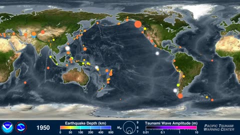
120 Years of Earthquakes and Their Tsunamis: 1901-2020
120 Years of Earthquakes and Their Tsunamis: 1901-2020
This animation shows every recorded earthquake in sequence as they occurred from January 1, 1901, through December 31, 2020, at a rate of 1 year per second.
More geography related videos here
https://rumble.com/playlists/cYA64Dyo9DY
211
views
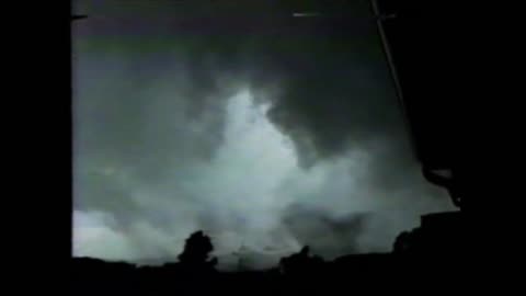
Massive Parkersburg, IA EF5 Tornado May 25, 2008
Cell phone video taken just before hitting town
The 2008 Parkersburg, Iowa tornado was an extremely powerful EF5 wedge tornado that devastated portions of northeast Iowa, most notably the town of Parkersburg, Iowa during the afternoon of May 25, 2008, resulting in catastrophic damage and nine fatalities
154
views
1
comment

Andover, Kansas F5 Tornado April 26, 1991 Aftermath
F5 tornado tore through Andover, Kansas, killing 17 people
From April 26 to 27, 1991, multiple supercells across Oklahoma and Kansas led to a regional tornado outbreak. Forced by a potent trough and focused along a dryline, these distinct thunderstorms moved northeast through a moist and highly unstable environment. A total of 55 tornadoes were confirmed, many of which were strong, F2 or greater on the Fujita scale. A widely documented F5 tornado tore through Andover, Kansas, killing 17 people. Additional fatalities occurred from significant tornadoes in other portions of Kansas and Oklahoma, with 21 deaths recorded in total. An F4 tornado was detected by a mobile doppler weather radar team which observed winds up to 270 mph (430 km/h) at the top of the funnel, the first time winds of F5 intensity were measured by radar, and the highest winds recorded by radar at the time. A news team filming an F2 tornado sought shelter under a Kansas Turnpike overpass, causing a misconception that overpasses can provide adequate shelter during a tornado. This outbreak occurred within a transition period for the National Weather Service and proved the value of NEXRAD radars, which were utilized in Oklahoma to provide advanced warning to residents.
166
views
Piedmont, Alabama F4 Killer Tornado March 27, 1994
Piedmont, Alabama F4 Tornado March 27, 1994
F4 tornado that devastated Piedmont, Alabama.n It struck the Goshen United Methodist Church right in the middle of the Palm Sunday service, collapsing the roof on the congregation and killing 20 people inside, including the Rev. Kelly Clem's 4-year-old daughter Hannah. Two other houses of worship were also destroyed mid-service.
174
views
Sandstorm Turns Day Into Night in a Matter of Minutes
Sandstorm Turns a Day Into Night in a Matter of Minutes
174
views
1
comment
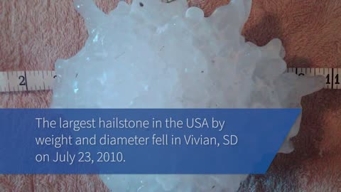
The Science of Hail - Meteorology - Weather Basics
Chunks of ice that fall from the sky can cause serious damage to property, and injuries to people and animals. But how does hail form?
Hail is a form of solid precipitation.[1] It is distinct from ice pellets (American English "sleet"), though the two are often confused.[2] It consists of balls or irregular lumps of ice, each of which is called a hailstone.[3] Ice pellets generally fall in cold weather, while hail growth is greatly inhibited during low surface temperatures.
Estimating Hail Size
Hail size is often estimated by comparing it to a known object. Most hailstorms are made up of a mix of different sizes, and only the very largest hail stones pose serious risk to people caught in the open. When reporting hail, estimates comparing the hail to a known object with definite size are good, but measurements using a ruler, calipers, or a tape measure are best.
Pea = 1/4 inch diameter
Mothball = 1/2 inch diameter
Penny = 3/4 inch diameter
Nickel = 7/8 inch
Quarter = 1 inch — hail quarter size or larger is considered severe
Ping-Pong Ball = 1 1/2 inch
Golf Ball = 1 3/4 inches
Tennis Ball = 2 1/2 inches
Baseball = 2 3/4 inches
Tea cup = 3 inches
Softball = 4 inches
Grapefruit = 4 1/2 inches
More More Meteorology Videos
https://rumble.com/playlists/JfAj918PQuc
91
views
3
comments

Hail storm in Damon Texas on 3/24/24 destroys 1,000’s of acres of solar farms
Hail storm in Damon texas on 3/24/24 destroys 1,000’s of acres of solar farms
Hail is a form of solid precipitation.[1] It is distinct from ice pellets (American English "sleet"), though the two are often confused. It consists of balls or irregular lumps of ice, each of which is called a hailstone. Ice pellets generally fall in cold weather, while hail growth is greatly inhibited during low surface temperatures.
Estimating Hail Size
Hail size is often estimated by comparing it to a known object. Most hailstorms are made up of a mix of different sizes, and only the very largest hail stones pose serious risk to people caught in the open. When reporting hail, estimates comparing the hail to a known object with definite size are good, but measurements using a ruler, calipers, or a tape measure are best.
Pea = 1/4 inch diameter
Mothball = 1/2 inch diameter
Penny = 3/4 inch diameter
Nickel = 7/8 inch
Quarter = 1 inch — hail quarter size or larger is considered severe
Ping-Pong Ball = 1 1/2 inch
Golf Ball = 1 3/4 inches
Tennis Ball = 2 1/2 inches
Baseball = 2 3/4 inches
Tea cup = 3 inches
Softball = 4 inches
Grapefruit = 4 1/2 inches
A photovoltaic power station, also known as a solar park, solar farm, or solar power plant, is a large-scale grid-connected photovoltaic power system (PV system) designed for the supply of merchant power. They are different from most building-mounted and other decentralized solar power because they supply power at the utility level, rather than to a local user or users. Utility-scale solar is sometimes used to describe this type of project.
836
views
6
comments
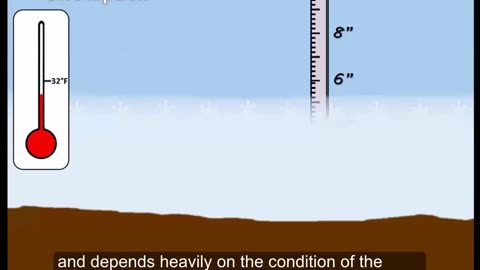
What is a Blizzard? Weather Basics - Meteorology
This is a brief video about the conditions needed for a blizzard
A blizzard is a severe snowstorm characterized by strong sustained winds and low visibility, lasting for a prolonged period of time—typically at least three or four hours. A ground blizzard is a weather condition where snow is not falling but loose snow on the ground is lifted and blown by strong winds. Blizzards can have an immense size and usually stretch to hundreds or thousands of kilometres.
More Meteorology Videos
https://rumble.com/playlists/JfAj918PQuc
58
views
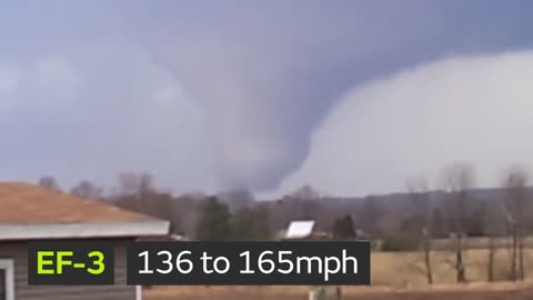
What is the Enhanced Fujita Tornado Scale - Weather Basics - Meteorology
Enhanced Fujita Scale or EF Scale, which became operational on February 1, 2007, is used to assign a tornado a 'rating' based on estimated wind speeds and related damage. When tornado-related damage is surveyed, it is compared to a list of Damage Indicators (DIs) and Degrees of Damage (DoD) which help estimate better the range of wind speeds the tornado likely produced. From that, a rating (from EF0 to EF5) is assigned.
Enhanced Fujita Scale
EFU Unknown No surveyable damage
EF0 65–85 mph Light damage
EF1 86–110 mph Moderate damage
EF2 111–135 mph Considerable damage
EF3 136–165 mph Severe damage
EF4 166–200 mph Devastating damage
EF5 >200 mph Incredible damage
The Enhanced Fujita scale (abbreviated as EF-Scale) rates tornado intensity based on the severity of the damage they cause. It is used in some countries, including the United States, Canada, France, China, and Mongolia
More Meteorology Videos
https://rumble.com/playlists/JfAj918PQuc
151
views

How Do Rainbows Form? - Weather Basics
How Do Rainbows Form?
rainbow is an optical phenomenon caused by refraction, internal reflection and dispersion of light in water droplets resulting in a continuous spectrum of light appearing in the sky. The rainbow takes the form of a multicoloured circular arc. Rainbows caused by sunlight always appear in the section of sky directly opposite the Sun. Rainbows can be caused by many forms of airborne water. These include not only rain, but also mist, spray, and airborne dew.
Rainbows can be full circles. However, the observer normally sees only an arc formed by illuminated droplets above the ground,[3] and centered on a line from the Sun to the observer's eye.
In a primary rainbow, the arc shows red on the outer part and violet on the inner side. This rainbow is caused by light being refracted when entering a droplet of water, then reflected inside on the back of the droplet and refracted again when leaving it.
In a double rainbow, a second arc is seen outside the primary arc, and has the order of its colours reversed, with red on the inner side of the arc. This is caused by the light being reflected twice on the inside of the droplet before leaving it.
More Meteorology Videos
https://rumble.com/playlists/JfAj918PQuc
165
views
3
comments
F4 tornado strikes Bullitt County, KY - May 28, 1996
F4 tornado strikes Bullitt County, KY - May 28, 1996
F-4 tornado crossed through our communities causing more than $100,000,000 in damage. Miraculously no one was killed and only 10 people were hurt by this tornado that was on the ground for 30 miles. At its widest it was half a mile wide!
Violent Tornado videos
https://rumble.com/playlists/GYezmaWENak
215
views
4
comments

EF4 Tornado Hitting the St. Louis International Airport April 22, 2011
On April 22, 2011, a violent EF4 tornado, with winds of 170 mph (270 km/h), struck the St. Louis metropolitan area. The tornado, which was the strongest to hit St. Louis County or City since January 1967, moved through many suburbs and neighborhoods, damaging and destroying many homes and businesses. The worst damage was in the Bridgeton area, where a few homes were completely leveled. In its 21.3-mile (34.3 km) track across the St. Louis metropolitan area, the tornado damaged thousands of homes, left thousands without power, and caused heavy damage to St. Louis Lambert International Airport, closing it for nearly 24 hours.
More violent tornado videos
https://rumble.com/playlists/GYezmaWENak
535
views
1
comment

The Science Behind Lightning - Meteorology
The Science Behind Lightning
You already know “When Thunder Roars, Go Indoors” and “See A Flash, Dash Inside!” But do you know what causes lightning and thunder in the first place?
More Meteorology Videos
https://rumble.com/playlists/JfAj918PQuc
83
views