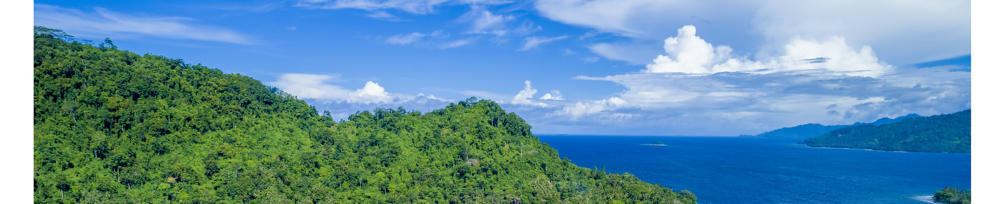

05 Flying Illegally from Jackson Hole, Wyoming to Grand Canyon, Arizona
This is the fifth leg of a planned flight around the world, ignoring regulations, navigating only by pilotage while using live weather. In this episode, we depart from Jackson Hole, Wyoming visiting Arches National Park, Dead Horse Point State Park, 4 Corners, Shiprock, Monument Valley, Navajo Mountain, and checking out the eastern half of the Grand Canyon while Otto discusses Kincaid's discovery of a vast underground lost city of an ancient advanced civilization containing artifacts that resemble ancient Egyptian and Eastern relics.
Jackson Hole Airport Scenery by JustOkayPilot:
https://flightsim.to/file/1453/jackson-hole-airport-kjac
Grand Canyon National Park Airport Scenery by JustOkayPilot:
https://flightsim.to/file/759/grand-canyon-national-park-airport-kgcn
VOR pic by Timkal
https://commons.wikimedia.org/wiki/File:Resolute_Bay_VOR.jpg
GPS (AMOS-5 Satellite) pic by Andrzej Olchawa
https://commons.wikimedia.org/wiki/File:AMOS-5_Satellite_--_with_star_background.jpg
Otto Avatar by krcustoms
https://flightsim.to/file/29606/otto-pilot-avatar
Cessna 310R by Blackbird Simulations
https://blackbirdsims.com/
Music (in play order):
"I can Change" (Instrumental) by A Gorgeous Feeling
"Mind Field" by Remember the Future
"Seven Days of Flying" by Remember the Future
"I can Change" (Vocal) by A Gorgeous Feeling
"Scouting" by Eveningland
"Darkness is Coming" by Kevin MacLeod is licensed under a Creative Commons Attribution 4.0 license. https://creativecommons.org/licenses/by/4.0/
Source: http://incompetech.com/music/royalty-free/index.html?isrc=USUAN1100584
Artist: http://incompetech.com/
64
views
Celestial Navigation to Howland Island (4K)
This was just meant to be a little video demonstrating how one might navigate an aircraft with just the sun, a clock, an averaging sextant, an almanac, and a compass. This isn't meant to be a tutorial despite how tedious this video might get at times--at least I refrained from demonstrating crab angle calculations and other minutia. After all, I'm still learning celestial navigation myself--am a complete newbie--learning primarily from Electron Volt's tutorial he's included with his sextant app on flightsim.to (See link below).
Using PMDG's excellent model of the DC-6 to fly this 7 hour flight. You can purchase from their website here: https://pmdg.com/pmdg-dc-6-for-msfs/
As stated in the video, Howland Island was chosen as a destination not only because of the historical aspect of being associated with Amelia Earhart and Fred Noonan's attempt, but because that island truly does pose a challenge, as it's so tiny and FLAT. I added some simple scenery here showing three gravel runways. All but the longest runway was ready for operation when Amelia and Fred departed. This can be downloaded here: https://flightsim.to/file/28052/howland-island-kamakaiwi-field
I chose Aropa Airport as the departing airport--in part because I called the area home the first 18 years of my life, and upgraded the airport a little from its default: https://flightsim.to/file/22004/aropa-kieta-airport-aykt
The Sextant and Drift Meter simulated here, was written by "Electron Volt". You can find these two apps for Microsoft Flight Simulator here:
CellNav for MSFS: https://flightsim.to/file/17738/celnav-for-msfs-celestial-navigation-sextant
Drift Meter for MSFS: https://flightsim.to/file/19402/simple-driftmeter-for-msfs
Ships used in Howland Island Scenery was used with with permission from Henrik Nielsen. To download these ships and their AI to use with MSFS, please click here: https://flightsim.to/file/9529/global-ai-ship-traffic-msfs-v1
"Little NavMap" by Alexander Barthel is a free mapping app, which was used in this video. It is feature rich and seamlessly connects with Flight Simulator (and other simulators). You can download it for free from: https://www.littlenavmap.org
The Nautical Almanac
https://thenauticalalmanac.com/
Music:
"Seven Days of Flying" by Remember the Future
"Epic Moments" by Immersive Music
"Exhale" by Jeremy Blake
"Saving the World" by Aaron Kenny
"Inception" by Aakash Gandhi
"Stranger Danger" by Francis Preve
Darkness is Coming by Kevin MacLeod is licensed under a Creative Commons Attribution 4.0 license. https://creativecommons.org/licenses/by/4.0/
Source: http://incompetech.com/music/royalty-free/index.html?isrc=USUAN1100584
Artist: http://incompetech.com/
122
views
1
comment
04 Flying Illegally from Scottsbluff, Nebraska to Jackson Hole, Wyoming
This is the fourth leg of a planned flight around the world, ignoring regulations, navigating only by pilotage. In this episode, we depart from Western Nebraska Municipal and visit Mount Rushmore, Crazy Horse Monument, Devils Tower, and Old Faithful before landing at Jackson Hole. This was flown using live weather. Otto explains some features along the way.
VOR pic by Timkal
https://commons.wikimedia.org/wiki/File:Resolute_Bay_VOR.jpg
GPS (AMOS-5 Satellite) pic by Andrzej Olchawa
https://commons.wikimedia.org/wiki/File:AMOS-5_Satellite_--_with_star_background.jpg
Otto Avatar by krcustoms
https://flightsim.to/file/29606/otto-pilot-avatar
Cessna 310R by Blackbird Simulations
https://blackbirdsims.com/
Music: "The Rising" by Aakash Gandhi
19
views
2
comments
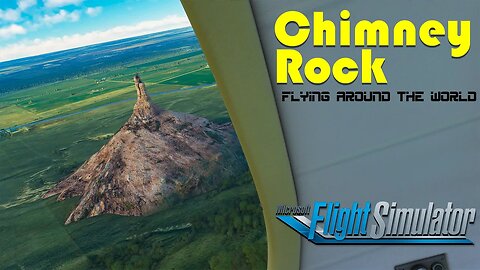
03 Flying Illegally from Hermann, MO to Scottsbluff, NE
This is the third leg of a planned flight around the world, ignoring regulations, visiting various points of interest, navigating only by pilotage and celestial navigation. In this episode, we depart from Hermann Municipal and visit Chimney Rock, lining us up for Runway 30 into the nearby Western Nebraska Regional airport. This was flown using live weather--with lots of clear air turbulence.
VOR pic by Timkal
https://commons.wikimedia.org/wiki/File:Resolute_Bay_VOR.jpg
GPS (AMOS-5 Satellite) pic by Andrzej Olchawa
https://commons.wikimedia.org/wiki/File:AMOS-5_Satellite_--_with_star_background.jpg
Otto Avatar by krcustoms
https://flightsim.to/file/29606/otto-pilot-avatar
Cessna 310R by Blackbird Simulations
https://blackbirdsims.com/
14
views
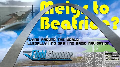
02 Flying Illegally from Meigs, Chicago, IL to Beatrice, NE (well, that was the plan).
This is the second leg of a planned flight around the world, ignoring regulations, visiting various points of interest, navigating only by pilotage and celestial navigation. In this episode, we depart from the legacy Meigs airport, and start heading west. Of course, in order to continue west, we must fly through the "Gateway to the West" in St. Louis. This was flown using live weather--which caused some problems.
We also compare/contrast the graphics around Chicago from subLogic's Flight Simulator II from 40 years ago.
Credits:
Gateway Arch by Mobilus In Mobili
https://creativecommons.org/licenses/by-sa/2.0/deed.en
https://commons.wikimedia.org/wiki/File:Gateway_Arch_St._Louis_from_Illinois_%2834133084122%29.jpg
VOR pic by Timkal
https://commons.wikimedia.org/wiki/File:Resolute_Bay_VOR.jpg
GPS (AMOS-5 Satellite) pic by Andrzej Olchawa
https://commons.wikimedia.org/wiki/File:AMOS-5_Satellite_--_with_star_background.jpg
Commodore 64 emulator with Sublogic Flight Simulator II:
https://archive.org/details/Flight_Simulator_II_1984_Sublogic
Otto Avatar by krcustoms
https://flightsim.to/file/29606/otto-pilot-avatar
Cessna 310R by Blackbird Simulations
https://blackbirdsims.com/
25
views
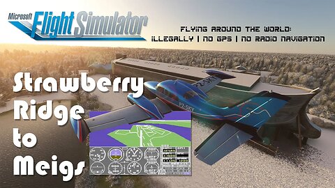
01 Illegally flying from Strawberry Ridge,NC to Meigs Airfield, IL
This is the first leg of a planned flight around the world, ignoring regulations, visiting various points of interests, and navigating only by pilotage and celestial navigation. In this first episode, we depart Strawberry Ridge and fly to the now non-existent Meigs airfield in tribute of the first virtual airport I ever took off from. Along the way, we hope to find Noah's Ark. This was flown using live weather.
Credits:
Illustrations used under creative commons license:
https://creativecommons.org/licenses/by-sa/2.5/
Commodore 64: https://commons.wikimedia.org/wiki/File:Commodore64.jpg
Noah's Ark:
https://www.vecteezy.com/vector-art/3560381-animals-on-noah-s-ark-with-sea-wave-isolated-on-white-background
VOR:
https://commons.wikimedia.org/wiki/File:Resolute_Bay_VOR.jpg
GPS:
https://commons.wikimedia.org/wiki/File:AMOS-5_Satellite_--_with_star_background.jpg
Commodore 64 emulator with Sublogic Flight Simulator II:
https://archive.org/details/Flight_Simulator_II_1984_Sublogic
Otto Avatar by krcustoms
https://flightsim.to/file/29606/otto-pilot-avatar
Cessna 310R by Blackbird Simulations
https://blackbirdsims.com/
77
views
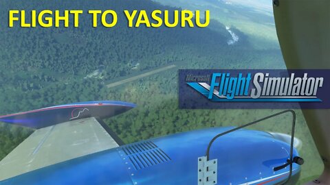
Flight from Aiyura to Surisil (Yasuru)
This is a somewhat whimsical flight (okay, this is Microsoft/Asobo Flight Simulator--it's all whimsical) from Aiyura airport in the Eastern Highlands of Papua New Guinea to an airstrip that my dad and his colleague, "Uncle" Jerry Allen, supervised the construction of, circa 1962.
This 1,970 foot long airstrip in the area that was known as Surisil (now Yasuru) which was given the ICAO code AYYR. Like many bush runways constructed in Papua New Guinea it has since closed, and is now occupied by village houses.
One benefit of MSFS is that one can create scenery to better visualize what was once there.
The Cessna 310R by Milviz / Blackbird Simulations used in this flight, is one of the best planes offered for the sim, with about 200 components that are tracked for wear and tear (and thus probability of failure); depending on how well you fly from one flight to the next... even the paint job gets dirty over time. This is not exactly a bush plane and anything but STOL; with very poor short soft field performance--but that only adds to the "challenge" and drama of flying into an area like this.
9
views
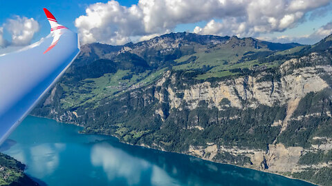
Soaring the Swiss Alps
Sailplane ride in a Duo Discus XLT out of Schanis, Switzerland.
Music: "The Rising" by Aakash Gandhi
11
views
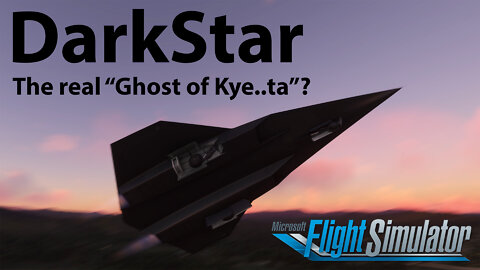
DarkStar (the real "ghost of Kye..ta"?)
A silly little flight in a "DarkStar"; a plane actually designed by Lockheed Engineers (perhaps a variation of the SR-72 concept), as featured in "Top Gun: Maverick".
This flight features basic technique for climbing up to 275,000 feet at Mach 10. Asobo's Microsoft Flight Simulator does a great job once again with the atmospheric effects and rendering of the earth at such a high altitude. The glow of the aircraft heated at such a high speed is a lovely touch too. This aircraft isn't exactly "study level" (it is a fictional (at least officially-ha) aircraft afterall); but it's obvious some great effort was put into many details on this aircraft.
This flight from Aiyura (in the Eastern Highlands of Papua New Guinea) to tropical shores of Kieta, Autonomous Region of Bougainville, (A flight I've done many times in a Cessna 402C as a passenger), is for somewhat personal reasons, (plus I have drone footage of both areas)... This distance doesn't really show the full benefit of hypersonic flight, as the time it took to accelerate and decelerate for this 700 mile flight took almost as long as flying four times as far, coast to coast across the USA.
==Credits==
Scenery:
Airyura Airport by johndoe3278
https://flightsim.to/file/25144/aiyura-airport
Kieta Airport by Skyborne Visions
https://flightsim.to/file/22004/aropa-kieta-airport-aykt
Livery:
Airbus A320neo "Air Niugini" by TheMaharaja
https://flightsim.to/file/2438/air-niugini
Music (in play order):
"Mind Field" by Remember the Future
"Seven Days of Flying" by Remember the Future
"Saving the World" by Aaron Kenny
43
views
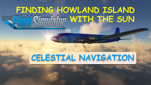
Celestial Navigation to Howland Island (4K)
NOTE: This video never seemed to process to it's full 4K potential... So I've re-uploaded here: https://rumble.com/v30h93k-celestial-navigation-to-howland-island-4k.html
This was just meant to be a little video demonstrating how one might navigate an aircraft with just the sun, a clock, an averaging sextant, an almanac, and a compass. This isn't meant to be a tutorial despite how tedious this video might get at times--at least I refrained from demonstrating crab angle calculations and other minutia. After all, I'm still learning celestial navigation myself--am a complete newbie--learning primarily from Electron Volt's tutorial he's included with his sextant app on flightsim.to (See link below).
Using PMDG's excellent model of the DC-6 to fly this 7 hour flight. You can purchase from their website here: https://pmdg.com/pmdg-dc-6-for-msfs/
As stated in the video, Howland Island was chosen as a destination not only because of the historical aspect of being associated with Amelia Earhart and Fred Noonan's attempt, but because that island truly does pose a challenge, as it's so tiny and FLAT. I added some simple scenery here showing three gravel runways. All but the longest runway was ready for operation when Amelia and Fred departed. This can be downloaded here: https://flightsim.to/file/28052/howland-island-kamakaiwi-field
I chose Aropa Airport as the departing airport--in part because I called the area home the first 18 years of my life, and upgraded the airport a little from its default: https://flightsim.to/file/22004/aropa-kieta-airport-aykt
The Sextant and Drift Meter simulated here, was written by "Electron Volt". You can find these two apps for Microsoft Flight Simulator here:
CellNav for MSFS: https://flightsim.to/file/17738/celnav-for-msfs-celestial-navigation-sextant
Drift Meter for MSFS: https://flightsim.to/file/19402/simple-driftmeter-for-msfs
Ships used in Howland Island Scenery was used with with permission from Henrik Nielsen. To download these ships and their AI to use with MSFS, please click here: https://flightsim.to/file/9529/global-ai-ship-traffic-msfs-v1
"Little NavMap" by Alexander Barthel is a free mapping app, which was used in this video. It is feature rich and seamlessly connects with Flight Simulator (and other simulators). You can download it for free from: https://www.littlenavmap.org
The Nautical Almanac
https://thenauticalalmanac.com/
Music:
"Seven Days of Flying" by Remember the Future
"Epic Moments" by Immersive Music
"Exhale" by Jeremy Blake
"Saving the World" by Aaron Kenny
"Inception" by Aakash Gandhi
"Stranger Danger" by Francis Preve
Darkness is Coming by Kevin MacLeod is licensed under a Creative Commons Attribution 4.0 license. https://creativecommons.org/licenses/by/4.0/
Source: http://incompetech.com/music/royalty-free/index.html?isrc=USUAN1100584
Artist: http://incompetech.com/
142
views
2
comments
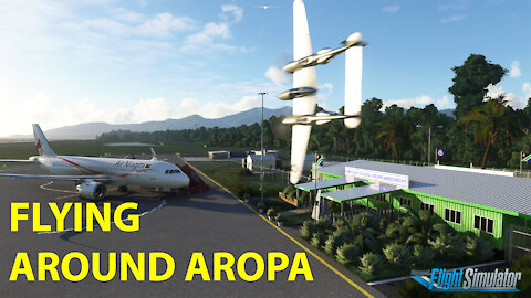
Buzzing around Aropa Airport on Bougainville Island
This is just a little whimsical video featuring my attempt at modelling the terminal for the Aropa Aerodrome, including an abbreviated in-sim tour of the area I was raised in, using the Lockheed P-38L Lightning made by Flying Iron Simulations: https://flyingironsimulations.com/ and Microsoft's Asobo Flight Simulator 2020.
The custom scenery for the airport that services central Bougainville Island can be found here: https://flightsim.to/file/22004/aropa-kieta-airport-aykt
Flag model by trfsto, ("Windy Things" https://flightsim.to/file/14024/windy-things" ) re-textured with Bougainville Flag (plus a newly proposed Bougainville flag found online).
The Air Niugini Livery was done by TheMaharaja https://flightsim.to/file/2438/air-niugini
The Solomon Airlines Livery was done by ahsaul https://flightsim.to/file/15405/cessna-208b-grand-caravan-solomon-airlines-4k-fictional
49
views
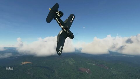
At Strawberry Ridge in a F4U Corsair
Airstrip profile used from JAARS' diagrams for changing slope, altitude and runway width combined with drone mapping taken spring of 2018. The house and shed near top of the hill are custom located. The house was a beginner's attempt at 3D modelling in Blender for game use. The offset hangar area north east of the runway and other nearby buildings are AI generated by Asobo / Microsoft.
This is just a little showcase of the privately owned grass runway near Little Switzerland, North Carolina that offers an interesting slope varying from 4 to 16% grade, and where missionary pilots often hone their skills. I thought it might be interesting to try operating this Goodyear variant of the F4U Corsair in as light as possible configuration (only carrying 25 gallons in the reserve tank) to take off and land. This Flight Simulator 2020 addon from Milviz (https://milviz.com/flight/products/FG1D2020/index.php) does a pretty good job of simulating just how hard this aircraft is to operate at low speed and high torque while not throwing a rod.
5
views
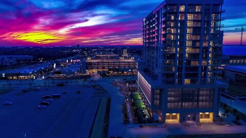
12 COWBOYS WAY
This is a mixed-use residential building which is part of the Cowboys HQ campus known as "The Star". KSC (Knott Smith Construction www.ksc-us.com) installed the screens on the parking garage, clad the porte cochere with ACM and the columns around the pool deck located above the parking garage.
9
views